-
Comment by Nick Hare on January 17, 2012 at 18:43
-
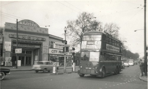
As far as I can tell, this is a view from the corner of Stroud Green Road, looking North East up Seven Sisters Road, with the building on the far right being on the corner of Blackstock Road (and now largely occupied by the excellent Happening Bagel Bakery). The pub-type building on the far left is (I think) now the Twelve Pins. This raises a number of questions. First, what is the Victorian-looking red tower near the centre of the picture? And where did the road turning off to the left (which is now the pavement in front of part of the Twelve Pins) lead? The view is very approximately this:
-
Comment by StephenBln on January 17, 2012 at 19:10
-
@Nick Hare The road turning off to the left is the entrance of the tram depot.. later cinema and bingo hall.
You can just about make out the tracks turning into the depot.
@Hugh I certainly didn't pluck the names out of 'thin air' - when I find the books, I'll give you the refs.. That's what I meant before about wiki - the pages tend to get taken over by certain groups of people.. and their need to prove that it's serious info causes much of it to be lost.
-
Comment by Nick Hare on January 17, 2012 at 19:59
-
So does that mean that Rowan's Bowl now occupies the site of the old tram depot? There's something slightly reminiscent of a tram depot about a bowling alley - all those parallel tracks. I like it. If that's true and I'm not confused about the location.
-
Comment by irene rose neil on January 17, 2012 at 20:48
-
thanks guys most informative.I am old enough to remember the Majestic Ballroom which had also been an ice-rink.I I think but not too sure that tower was something to do with a water pump tower.
-
Comment by pamish on January 17, 2012 at 21:08
-
Seven hornbeams were replanted in 1997. They are doing fine.
The trees have always been on Page Green, not at Finsbury Park. It''s likely that the site taps into an old site of worship/power. Perhaps I'm living on a ley line again (I once lived on the Ridgeway. What comes around...)
-
Comment by StephenBln on January 17, 2012 at 21:25
-
@Irene I remember the Majestic too! Here's a shot from 1961, sort of half-way between the postcard above and today. You can still make out the entrance to the (horse) tram depot.
Note the double crested Borough boundary sign on the trolleybus pole 'County of Middlesex' 'Borough of Hornsey' - all Middlesex boroughs had these.
http://www.flickr.com/photos/isarsteve/6689555463/in/photostream/li...
-
Comment by irene rose neil on January 17, 2012 at 21:33
-
wonderful photo thanks
-
Comment by StephenBln on January 17, 2012 at 21:38
-
One comment seems to have completely disappeared:
The postcard clearly illustrates the transport situation at Finsbury Park at that time. This was the boundary not only between the Borough of Islington & Hornsey UDC, but also the counties of London & Middlesex.
Trams operated by the London County Council terminated here and were run into the depot. In the background are the M.E.T. (Middlesex) trams. The systems/tracks were not even connected when the photo was taken.. first connected with through services in 1912.
The pavements and roadways are full with transfer passengers (tram & tube). The Piccadilly Line passengers had to wait until the 1930s before there was no more need to transfer here.
-
Comment by StephenBln on March 11, 2012 at 17:16
-
Very nice souvenir book Anne..
Add a Comment
- ‹ Previous
- 1
- 2
- Next ›
© 2026 Created by Hugh.
Powered by
![]()

You need to be a member of Harringay online to add comments!
Join Harringay online