Harringay, Haringey - So Good they Spelt it Twice!
St Anns Rd Overground Station?
After a visit to St Ann's Hospital site, I saw potential for a new overground station for the Gospel Oak line (I lived beside as a student,) but didn't realise a station had been designed last century for the area called 'St Ann's Rd', (closed in 1942.)
Reinstating the station would provide direct links to three of North London's Hospitals,
The Royal Free, The Whittington and St Ann's Hospitals. The surrounding area has a catchment of 24,000 people, over the three wards of West Green, St Ann's and Seven Sisters, 32,000 if you include Harringay.
St Ann's, West Green and Seven Sisters have lost two overground stations, St Ann's road and West Green Rd Stations, (through 'modernisation,') which has had a huge impact on the local economy over the past seventy years.
A new station would revitalise the area and accessibility to first class health facilities across north london and Tottenham. The Warehouse district would also benefit with added transport connections, where critical mass will only increase as housing pressures are felt by the area, another reason why land retained for hospital services is so crucial to a growing population with increasing health needs.
St Ann's Station demolished 2012: (Scroll down to bottom of page)
http://www.abandonedstations.org.uk/Goblin2.html
Hermitage Rd could be an ideal site, massively improving its PTAL, Public Transport Accessabilty Rating, or reinstating the 19th C station on its original site.
Google view of Hermitage Rd Station site: (if street view doesn't load click on google street view link, or cut and paste full link below.)
Site: Corner of Hermitage and Templeton Rd's N15.
https://www.google.co.uk/maps/@51.5791461,-0.0869923,3a,75y,213.61h...!3m4!1e1!3m2!1sl0nR3DiKAvZNTLuelJ2PPA!2e0
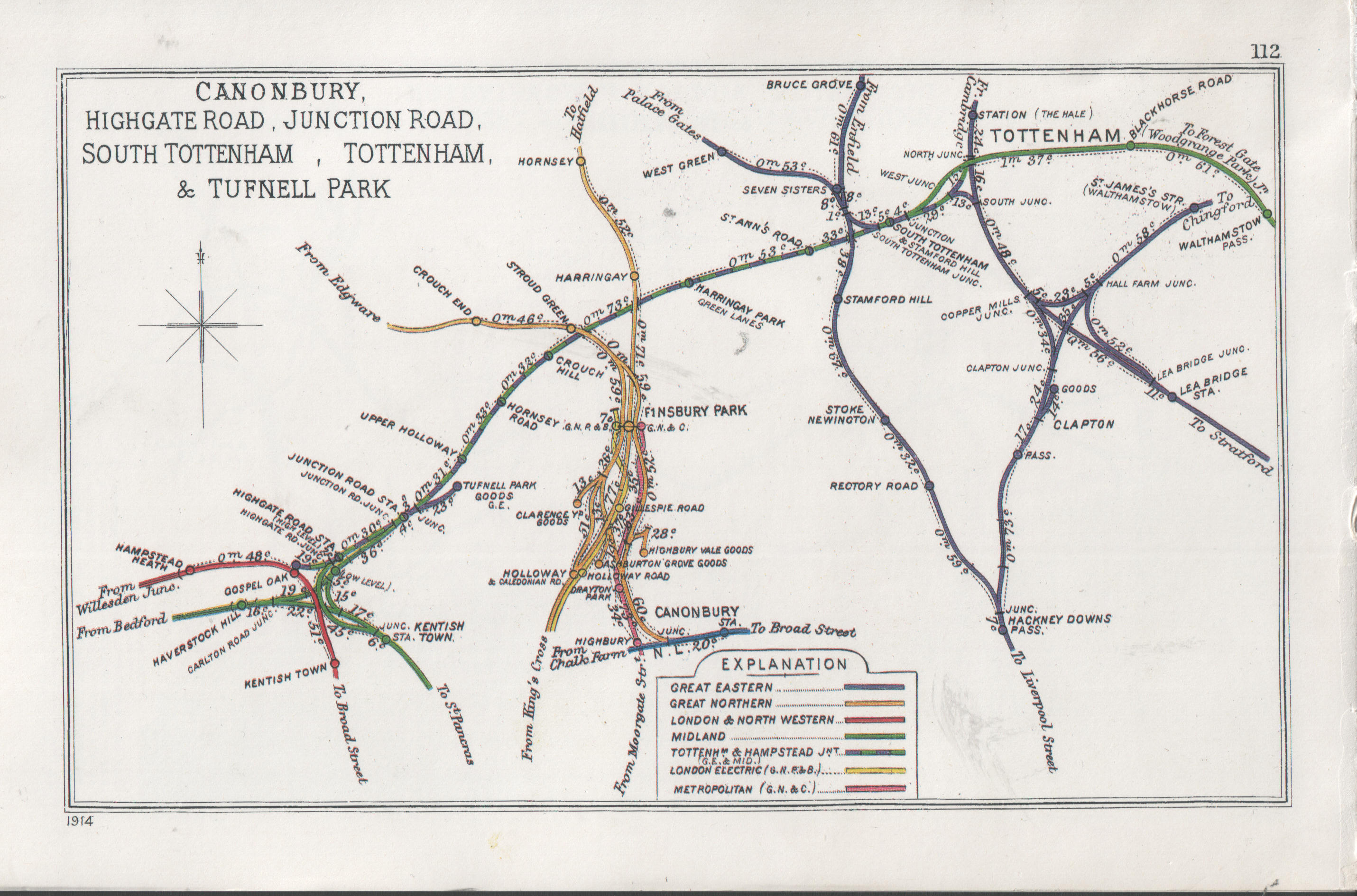
Train Route Map 1914:
http://upload.wikimedia.org/wikipedia/commons/3/3a/Canonbury%2C_Hig...
Background to Barking Line and old rail route map in red:
http://en.wikipedia.org/wiki/Gospel_Oak_to_Barking_Line
Westfield White City, new Overground Station: Comparable Site.
Overground:
A new National Rail station has been constructed for London Overground customers at Shepherds Bush. The station, on the east side of the new Shepherd's Bush Interchange, is fully accessible and provides links to the Central line tube station, buses and taxis. The station provides direct connections to Willesden Junction, Kensington Olympia, West Brompton and Clapham Junction.
Services will run every 15 minutes in each direction Monday to Saturday, with between one and two trains per hour on Sundays.
Replies to This Discussion
-
Permalink Reply by Jayvee on
-
That's interesting, I'd also like to see that line better connected. It can't be that hard for them to run trains from gospel oak that go through Harringay and then go down to Clapton and on to the city using that line. The tracks even appear to cross from looking at maps. The st Ann's area is really ripe for redevelopment. I hope they don't throw away the opportunity with the predictable uninspiring proposals they have now. Have you noticed how few shops there are?
-
Permalink Reply by Abi on
-
Absolutely! I had no idea there was ever even a station there. Speaking as a local I think it's fair to say that this immediate area is a real anomaly in terms of the lack of shops, facilities, anything really - and it has never made sense to me. Anything that could open it up a little more would help, and a station is surely a place to start. I'd love to see it getting a stop on the overland - it could be so much better connected East to West.
-
-
Get in there quickly before the hospital sells the site to developers.
-
-
Yes, Matthew.
I don't know if your suggestion for a station on Hermitage Road has been considered before. It seems a good one, whatever happens to the St Ann's site and the Warehouse area. [I certainly don't agree with running down the hospital, which has been justified in part by saying that the transport links to it are bad, though they are good enough for Moorfields and the Whittington to have big clinics there]
Other people (eg on the LondonReconnections website for transport enthusiasts) have talked about the idea of re-opening the original station where the line crosses St Ann's Road. The trouble with that position would be that it's really close to the next station, South Tottenham. Your spot on the other hand is halfway between there and Harringay Green Lanes - and in a good place for the Hospital and any other stuff.
I couldn't make the link to Google Maps go there at first, but it worked by putting 51.5790799,-0.0870631 into the search box.
-
Permalink Reply by Robert Pike on
-
Good idea. I often walk down Hermitage Road and under the rail bridge and look at the underused land in behind the big fence and wonder at its greater potential for something like a station. I think that line and the Seven Sisters line south to Hackney provide excellent connections. I think there is great scope (without considering engineering...etc) in the area to join more of these up.
The post poses wider questions about the hospital site and how it can be more integrated and viable within the community. I have looked at the current proposals and don't think they are up to much i.e Shove hospital uses into one half and fill the other up with as much resi as possible! Obviously we are in an area where car parking spaces are limited in developments - doesn't necessarily mean it limits residents to owning cars. Something PTAL doesn't consider.
I think it is better to maintain all or the majority of the site for the hospital and look at stitching into that interventions like a station to improve it, something community related in the old Police Station, diagonal links across the site... Funnily enough the current masterplan indicates that the site has capacity for development - so why not develop it effectively and efficiently for a much better hospital.
Thanks Matt. You got me thinking of a Sunday!
-
-
It's a 'quarantine hospital' isn't it? Hence the huge wall around the premises and the lack of thoroughfare as a result.
I wonder if it could simply be redesigned in such a way that it doesn't have this feature, which essentially makes the East-West route more difficult and convoluted than it needs to be?
-
Permalink Reply by tania on
-
I agree, a better outlook as the the area and the requirements of residents and public health services, I still consider that an emergency hospital is required at St Ann's site and the wall is not so ancient and precious that is can't be taken down, it makes the site appear to be some sort of containment and not publicly accessible even though it is public land. With just a little vision so much could be done correctly for the area but it appears that vision is extremely lacking as all the building investors can see is profit, they don't care as to the quality of life of the new residents. The council staff whom are supposed to be protecting the public assets are just lame ducks & the MP's, just saying, money matters most.
-
Permalink Reply by matthew cuthbert on
-
Great to hear, your not the only one who has called for an emergency facility, raised last week at the latest CCG (Haringey Clinical Commissioning Group) meeting, and I think there is enough merit to explore this model, the NHS don't like it 'cause it cost cost costs, but this can be offset against the benefit of having a more essential service.
© 2026 Created by Hugh.
Powered by
![]()